
Saturday, April 30, 2011
Look it! hehehe
 I just looked at different categories to help us identify which sites should be focused on. We can discuss this at the meeting. As discussed earlier, the first 3 stops are tunnel stops. Only Canton is on surface.
 Check out this article! http://science.howstuffworks.com/engineering/civil/subway1.htm
This talks about how they construct tunnels, different methods, etc.
Friday, April 29, 2011
Check it.

Check it out.
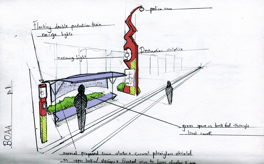
Archetype Station:
I was figuring: Hey, I'm investigating the site, we need an archetype station for renderings, why not take a stab at it? I based it partly off the Valley Metro stops, which are fantastic precedents based in Pheonix, AZ. They're functional, aesthetically pleasing and evocative of their function. They're basically a solar shade plane/frame fronted/backed by small triangular sun shade canopies, with art interwoven into both the fabric of the station and the ground surrounding it.
So the most pressing difference is weather. They don't get a lot of rain or snow in Pheonix. So what I did was to take an planar arcade and fold it into rowhouse-bay window bumps with benches on the diagonals and top it off with a low slope solar panel roof. The single plane profile makes it thin, the folding gives it stability and the ability to hold up a roof, while the roof itself offers both shade and power.
Not only that, but the design, because it's based on these windowesqe bays, is completely modular. You could even take a single bay and use it as a temporary bus stop (provided you anchored it using some sort of heavy base.)
Masts:
One of the important and so far neglected elements of the design are the masts. These are pretty simple, but come with street lamps and a single top light I call the Mast light. The Mast light flickers on whenever the train passes beneath it. This gives a visual indicator to both rail-goers and enthusiastic drivers as to the train's position, hopefully adding an element that it both dynamic and safety inducing.
Play:
One thing that just kind of happened was the idea of placing touchscreen panels into "table" blocks, and allow people to play various boardgames on them (checkers, chess, backgammon). I dunno, I just think this would be super cool. It kind of reminds me of those park chess games
Arch:
One element not in the rendering is the possible focal element of the station, an arch over where the crosswalk intersects the station. It might be nice to give a focal point to the linear design, and this arch or tower could also serve to display information/time/weather/whatever. Or be purely sculptural.
Art:
One takeaway idea I saw in the Valley metro was the seamless integration of art and station design. The "weft" of the planar element of the station allowed it to become a "loom" for art elements, while the ground and mosaic features/sculptures also played a major role. Without a doubt, individual artists and designers should be assigned individual stations to integrate a piece of artwork into. There's less wiggle room than in the AZ designs, but I think it's almost a given that it would be beneficial.
Signage:
Almost forgot... signage. I was thinking about Jenny's comment... with the something like "i am a bright orange sign w/ bold lettering designed to f*ck up your day." It's true. But any signage we put up will have to be Additional, not Instead Of. There are federal guidelines which are also adopted by states regulating the exact color, shape, font, and anything else you can think of. But that doesn't mean we can put up additional, more engaging signage (even on the same signpost) with graphic elements (multilingual stop signs with a big red hand on them) and cones with spiral reflective tape topped by bicycle reflectors or suchlike.
Wednesday, April 27, 2011
MEETING 4
time: Saturday 4/30, 6pm ish.
place: Dave's house
for dinner: spaghetti???
goals: to pick a site and design approach/concept
FOR REAL THIS TIME.
and to enjoy a night of knect dancing! (jesse...?)
place: Dave's house
for dinner: spaghetti???
goals: to pick a site and design approach/concept
FOR REAL THIS TIME.
and to enjoy a night of knect dancing! (jesse...?)
Monday, April 25, 2011
Noise reduction
Just a thought, so noise/sound is a wave frequency. So technically, if we can have an inverse wave, that can cancel it out right?
If we cover up the site after we work on them, it will definitely help with reducing the amount of dust blown into the air.
Traffic, can we somehow perhaps encourage carpooling to at least reduce the amount of traffic first? I will look at the sites closer and see how the traffic flows, how to re-route traffic.
Rainwater: i think we will definitely want to identify the lowest point in the site first to see where the water will go to? And then from where the lowest point is, the strategy may be different?
Sunday, April 24, 2011
Meeting 3 Recap: Preliminary Proposals for Potential Sites
These are proposals that Jesse and I discussed for surface construction, while applying them to the Rosemont stop. However, we noticed that these can be applied to any stop as well. So our proposal(s) will be issue-specific and applicable to all sites, but in the end, we will try to focus on implementing those ideas to one particular site/stop to argue our case more strongly. We still need to explore proposals addressing problems arising from underground construction. (Amanda, I know you've been working on that. ;) but we can all be thinking about possibilities too.) I apologize for the lack of images; I currently do not have a working scanner, but I should have our drawings up by tomorrow night!!!
Remember: proposals must address immediate construction issues. Assuming that construction will be taking place piece by piece, or in fragments, proposals should respond accordingly. Something mobile? flexible? modular? temporary/transient? We identified and addressed what we thought were the top 3 issues:
1. TRAFFIC
-where will traffic suck the most because of construction?
-how can we re-route traffic to keep flow smooth and steady?
-how can we keep pedestrians safe and informed?
-for vehicular traffic
2. RAINWATER MANAGEMENT

3. DUST/NOISE
1. Site Selection Trial 2:
Out of your four sites, pick one that will pose the most problems and disruptions from construction. (Don't make the mistake that I did, which was picking a site that was too much of a blank canvas and is actually furthest away from human contact and traffic....unless you can argue otherwise)
2. More Specific Proposals that will address the issues identified above, and/or others that find just as/even more pressing
it may be helpful to diagram those issues so that we can all easily, visually compare/constrast/matrix our cases and see what can be done
3. also, consider what can be done:
- pre-construction
-during construction
-post construction
***Edit: (Jesse)
Here's a post-sketch of some of the ideas we came up during the meeting... hopefully it illuminates the traffic bubble concept a little more clearly.

Remember: proposals must address immediate construction issues. Assuming that construction will be taking place piece by piece, or in fragments, proposals should respond accordingly. Something mobile? flexible? modular? temporary/transient? We identified and addressed what we thought were the top 3 issues:
1. TRAFFIC
-where will traffic suck the most because of construction?
-how can we re-route traffic to keep flow smooth and steady?
-how can we keep pedestrians safe and informed?
-for vehicular traffic
- around immediate construction zone, open up and transform former street parking lanes into regular driving lanes. These may create interesting slip-pocket spaces...need help with naming!!
- divert street parking to nearby vacant lots owned by retailers, or onto residential/commercial crossroads, while somehow subsidizing/compensating for retail owners and nearby residents
- use cool cones, glow-y things, interesting markings to delineate new lanes around construction zone.
- keep construction zone space-efficient: create a linear, mobile construction zone with complimentary storage unit
- encourage biking with new bike lanes, rent/share-a-bike lots
- introduce more free city circulator buses/routes
- sheltered crosswalks that can be info galleries and educational opportunities for people to be able to stay updated with construction; to be able to see what's going on thus far
- integrate mobile, modular street furniture into crosswalk designs that are easy for locals and construction workers to assemble/disassemble where needed--seating/tables for resting, waiting, viewing at medians, bike racks at the ends, etc.
- increase visibility of new/existing bus stops--make them bigger, redder, badder, with solar-powered lights, sculpture landmarks, bike racks, temporary container/nursery gardens or whatever else we think would be addressing relevant issues


2. RAINWATER MANAGEMENT

- use sandbags or some form of barrier to create a water retention zone that would redirect rainwater down to the green median that is proposed to exist between the two rails
- slope down and stagger terrain if slope is going in opposing direction
- cross-sectional-wise, slope terrain away from tracks to drain along the rail and potentially create linear greens
- do the same near sidewalks
- use leftover concrete rubble for drainage, foundations for more permanent stations, seating and retaining walls. (need to see Jesse's sketch of tiered retaining walls that could eventually become a mini amphitheater similar to the one by stamp at the college park campus!)
- ***these should probably be prepared before construction really gets started...
- speaking of leftover construction material/waste, how can we re-use/store this? Can they be used to build the urban/street furniture proposed above?
- wherever sidewalk allows it, push for micro pocket parks with drainage channels/slopage where needed


3. DUST/NOISE
- calls for protective barriers--dust: visual barrier; noise: auditory; green, etc
- installing historic Baltimore trompe-leouil facades over the construction site
- design stencils for local kids to use for a community/red line art project on walls around construction and/or on slots in bus stops
- make the water retention barriers also be used as plant holders to create a green barrier or a mobile nursery that could replanted somewhere in a nearby park when construction is done...
- in fact, after construction, these protective barriers could all be moved to new/more permanent homes in plazas, parks, etc, as collage pieces/wall sculptures/jungle gyms...whatever we can do with em.
- this may require research on dust/noise-resistant material
- subsidize businesses/homes to help them update their buildings with more energy-efficient and sound-resistant windows
- try to schedule heavy construction during off-hours on weekdays (10:30-3pm and after 5pm)
- weekends: all day; earlier the better to allow for nightlife and events--lectures, construction/neighborhood happy hours, etc.
- times need to be clearly communicated via billboards, lighting, graphics, etc
1. Site Selection Trial 2:
Out of your four sites, pick one that will pose the most problems and disruptions from construction. (Don't make the mistake that I did, which was picking a site that was too much of a blank canvas and is actually furthest away from human contact and traffic....unless you can argue otherwise)
2. More Specific Proposals that will address the issues identified above, and/or others that find just as/even more pressing
it may be helpful to diagram those issues so that we can all easily, visually compare/constrast/matrix our cases and see what can be done
3. also, consider what can be done:
- pre-construction
-during construction
-post construction
***Edit: (Jesse)
Here's a post-sketch of some of the ideas we came up during the meeting... hopefully it illuminates the traffic bubble concept a little more clearly.

Thursday, April 21, 2011
NEXT MEETING, UPDATES, AND REMINDERS!!!
hey everyone...don't mean to nag about this but...
the next meeting is:
time/date: Saturday, 4/23, 3pmish
location: either at Dave's house or mine. please say your preference! (i know jenny and amanda are skyping.)
please lemme know whether you can make it or not.
This meeting will be critical, as we will be selecting a design approach and site(s) for proposals. (we may have to schedule site visits soon too, or plan our own dates...) And we will begin making proposals, while discussing precedents, so drawing/tracing/diagramming will be involved. Bring your research, maps, trace, markers, scanners--anything and everything that will make this preliminary charette go smoothly! I know this might be awkward for jenny and amanda over skype--sorrrrry...
jenny, i know if that if you could apparate here you would...
amanda, i know this is bad timing and I'll try to give everyone an earlier notice so that we can better plan a time for everyone to physically meet up...esp for meetings like this.
lacey, if youre back in town, please try to make it if you can!
Thanks everyone! i know youre all reallly really busy! but just keep posting/reading/commenting on the blog when you can! esp so meetings can run more smoothly too (not that they haven't been that way). oh and if anyone's found any research on construction of lightrails/subways, the like, please post links too.
Looking forward to Saturday! =)
Bayview MARC station site proposal and related precedents...
 obstacles and opportunities:
-as questioned from our previous meeting, can a commuter/transfer station like Bayview MARC become a destination? How can we make "transfer as event" (Dave) ?
-multiple corridors/modes of transit meet here--the rail runs over Norfolk Suffolk Railyards (freight train?), below 895, tangent to the MARC train, and across Lombard after leaving the Marc station. Meanwhile, MTA buses and Bayview Campus shuttle buses run active.
Rather than just having a full-time parking lot for commuters (and construction workers?), how can this space be transformed by day/night? weekday/weekend?
Some quick collage speculations:

With so many corridors passing through this area, signage/communication about construction updates and related local events may be key. To add to Jesse's brainstorming list of local events that can help make these "temporary urban spaces" become more permanent but flexible and transforming:
-drive-in and walk-in talks/lectures held by the Bayview campus or other nearby neighborhoods
-transformative signage and urban furniture using salvaged construction materials perhaps--street lights, benches, bike racks, tables, etc...
RELATED PRECEDENTS

check this!
http://www.rebargroup.org/projects/pavementtoparks/
really liking the adaptive reuse of those garbage dumps into mobile tree/garden lots. Wonder what construction materials can be recycled and re-used on site?
and this!
http://www.rebargroup.org/projects/parkcycle/
Letting the community design/build mobile greens can give them the fun/freedom to flexibly change a public space into markets, meetings, tree plantings...or yoga sessions?
for really cool urbanism ideas, check out Lateral Architecture! particularly the slips project, where we could apply cool crosswalk patterning to provide traffic with clear direction
http://www.lateralarch.com/master.html
more images to come...
Monday, April 18, 2011
I Found Something...
****EDIT****
I found this lurking on the interwebs.
Full text at: nexus.umn.edu/Theses/ReubenCollins_ProfessionalPaper.pdf
It's a master's thesis about light rail impact mitigation strategies. I'm in the process of reading it, but here's a table near the end with the summary. Full descriptions of each measure are found on the actual paper. "...so then I found this thingie on the interwebs and it told me exactly what to do..."
****END EDIT*****
Been thinking... we need to win over both local communities and auto-users alike.
Here's some ideas for winning over communities....
-Involve Local Churches, Schools, Community Institutions:
Here's some ideas for winning over auto-users...
Here's some ideas for station/infrastructure improvement...
These improvements can take place in one of Four places...
-Nearby Pre-Existing Park/Open Space --> Community Event Space
-Nearby Boulevards and Greenways --> Linked Ped/Bic ecofriendly transit system w/ shared bikes, enhanced street infrastructure
-Exiting Station Plots --> Enhanced signage, enhanced aesthetics, more informationally utility, enhanced drainage
-Mini-lots --> Space for urban farms/bike share-stations, pocket parks and police/utility vehicle parking (for neighborhood patrols and infrastructure improvement)
Full Rosemont visual anaylsis at...
http://chimerapathogen.deviantart.com/art/BOAA-Rosemont-Station-205394060
Also this sketch:

This picture features a "Destination Marker"- large scale sculpture/structure which signals incoming trains, as well as lighting up to tell the community about ongoing events. These lights would also be placed at community centers (for example, a green light would light up during a farmer's market at both the station and the community event space (whose marker would be visible from the station.)

And this sketch: An urban garden on an empty plot only one block away from the Rosemont Station. Because of the nature of the block types, it's not that uncommon to have an empty plot or half plot on the end.
Trellises and banners along a scaffold walls, along with minimal landscaping into regular plots and concrete or cobbled walkways gives you a nice pocket urban farm- especially once you add in a little water storm water retention garden at the end. (note: forgot to draw flowers)
I found this lurking on the interwebs.
Full text at: nexus.umn.edu/Theses/ReubenCollins_ProfessionalPaper.pdf
It's a master's thesis about light rail impact mitigation strategies. I'm in the process of reading it, but here's a table near the end with the summary. Full descriptions of each measure are found on the actual paper.
 "...so then I found this thingie on the interwebs and it told me exactly what to do..."
****END EDIT*****
Been thinking... we need to win over both local communities and auto-users alike.
Here's some ideas for winning over communities....
-Involve Local Churches, Schools, Community Institutions:
- Community Charettes at churches and schools, involving local kids and parents, possibly with assistance from local colleges and technical schools/architecture schools
(you could even bus in UMCP/Georgetown architecture students) - Grassroots Art- Graffiti as art, celebrating the grittier side of urbanism, kids stenciling their own design on panels judged by a jury to be placed along construction or more permanent installations. Installation competitions painted open air.
- Subsidize Local Events: Open air dance/martial arts competitions, community information sessions, farmers markets, urban farming events for churches/schools, art markets- even before the first track is laid, to begin building the social base that would become habituated to visiting these community events.
- Feeding workers could be an opportunity: They could be bussed out to local restaurants and commercial centers. Alternatively, they could sign up in the morning for food from local restaurants, which could be delivered on site.
- Paneling Posters along the side of construction in some areas could advertise deals at local businesses. In addition, they could play host to paying advertisers, which would subsidize the cost of putting up the local business posters.
Here's some ideas for winning over auto-users...
- Offsite Parking- have construction workers park in designated offsite lots rented by local businesses and bussed into the construction sites.
- Off-Hour Construction: Construction during weekends and nighttime when possible, especially for light construction work (i.e. anything not involving heavy construction equipment.)
Here's some ideas for station/infrastructure improvement...
These improvements can take place in one of Four places...
-Nearby Pre-Existing Park/Open Space --> Community Event Space
-Nearby Boulevards and Greenways --> Linked Ped/Bic ecofriendly transit system w/ shared bikes, enhanced street infrastructure
-Exiting Station Plots --> Enhanced signage, enhanced aesthetics, more informationally utility, enhanced drainage
-Mini-lots --> Space for urban farms/bike share-stations, pocket parks and police/utility vehicle parking (for neighborhood patrols and infrastructure improvement)
Full Rosemont visual anaylsis at...
http://chimerapathogen.deviantart.com/art/BOAA-Rosemont-Station-205394060
Also this sketch:
This picture features a "Destination Marker"- large scale sculpture/structure which signals incoming trains, as well as lighting up to tell the community about ongoing events. These lights would also be placed at community centers (for example, a green light would light up during a farmer's market at both the station and the community event space (whose marker would be visible from the station.)

And this sketch: An urban garden on an empty plot only one block away from the Rosemont Station. Because of the nature of the block types, it's not that uncommon to have an empty plot or half plot on the end.
Trellises and banners along a scaffold walls, along with minimal landscaping into regular plots and concrete or cobbled walkways gives you a nice pocket urban farm- especially once you add in a little water storm water retention garden at the end. (note: forgot to draw flowers)
Sunday, April 17, 2011
BOAA April 18 Meeting
Hello everyone,
This here’s a summary of the last meeting, more or less.
April 18th:
• -Centers for Medicare and Medicaid Services, Security Square, Social Security Administration, I-70 Park-and-Ride.
o -Overview:
• -Above ground rail; Primarily commuter destinations- high traffic stops people just passing through.
• -Surrounded by Office Parks and Low Density Middle to Low Income Residential.
o -Discussion Subjects:
• Transfer as an event: do we attempt to make people more aware of their environment as they are passing through?
• Rainwater Gardens: There is a possibility to integrate rainwater drainage into gardens that define and enliven the spaces around a station.
• Community Empowerment: Is there room for local commercial opportunity at or near the stops?
• Street Vendors: Passes for street vendors? provides local employment, provides convenient impulse shopping for commuters, may or may not rely on built in community space.
• Mobile Farmer’s Markets: The nature of the light rail allows markets to “travel” from station to station on different days? Urban farming was also mentioned, integrating plots of land near the station or on station grounds to act as community gardens.
• Community Space: Will be necessary for any kind of event. Where are existing community spaces? Are they within a close walk?
• Integrated vs. Existing: Does community space need to be integrated, in part, into the stations? How do we inform the community about the events and encourage participation?
• Traffic Patterns: Rail is disruptive to automotive traffic, particularly left hand turns.
• Signage Solution: Signage is going to be important: how will people know when to stop, when to go?
• Construction Schedules: In addition: how are you going to inform people about closings and construction schedules. What roads are going to be congested?
• LED Bustops: One possibility would be incorporating LED panels into existing bus stops explaining closures, bus times.
• -Edmondson Village, Allendale, Rosemont, West Baltimore MARC
o -Overview:
• Primarily medium density residential destinations with light commercial along the boulevards. Above ground rail located along long, high capacity east-west roads.
o -Discussion Subjects:
• Security: Security is going to be a concern. Lighting, encouraging police presence and/or “blue light” surveillance could be parts of a solution.
• Construction and Community: How do we integrate the community and school age children into the construction process, aside from using them as forced labor?
• MICA and Schools: There is MICA involvement: they could be used to develop color schemes and stencils, which school kids could use either on specific areas of the stations or on the boards lining the construction.
• -Harlem Park, Poppleton, University Center, Charles Center
o -Overview:
•
o -Discussion Subjects:
• Disparate Green Spaces: Multiple green spaces scattered across the city. How do we unify them?
• Unified by landscaping and Replacement: Take empty lots and fill them in with green space, use landscaping to provide a sense of unity between the parks.
• -Inner Harbor, Inner Harbor East, Fells Point, Canton
o -Overview:
• Waterfront.
• Previously industrial.
• Now high density commercial and mixed use.
• Also: Historic and diverse neighborhoods which have undergone gentrification or are in the process of being gentrified.
o -Discussion Subjects:
• Promenade: Is there an existing waterfront-long promenade?
• Extended Promenade: Would it be possible to create one to encourage green transit and unify the waterfront? Either through greenway or boardwalk.
• Backlash: Will there be extensive backlash from some neighborhoods? How does one deal with the problem?
• Test Rail: Testing the rail system on a smaller section to show the viability of the system first.
• Tailings: tunnel tailings and runoff could be a potential environmental problem.
• Harbor Greenspace Creation: Creation of waterfront green spaces using mined tailings from the tunnel construction.
• Construction Mitigation: How do you mitigate construction effect in historic neighborhoods?
• Historic Façade: You could put on screening elements depicting historic Baltimore, showing things as they existed one hundred years ago.
• -Canton Crossing, Highlandtown, Bayview MARC, Bayview Campus
o -Overview:
• Already the site of intense proposed and constructed mixed use, transit oriented development.
• Like Fells point and Canton, storied and varied neighborhoods.
o -Discussion Subjects:
• Green Transit: How do we encourage other forms of green transit?
• Bike Sharing: “Share a bike” programs have been successful in other cities, installing them at red line stations would probably be a good idea.

Saturday, April 16, 2011
Relevant Precedent Article of Joy
To start, I stumbled across this article I thought we all might enjoy and is relavant to the task at hand. Get inspired:
http://walyou.com/cool-bus-stops-world/
And this:
I thought this was valuable information from real people about walking radius as a urban design standard vs real world practicality.
View Red Line/Site Analysis in a larger map
That should link you. Its a work in progress. FYI it's actually pretty helpful to asses/make notes right in google maps. If only they had a way to draw circles...
Southeast Red Line Stops Site Analysis
 Overall, lots of urban renewal/development is currently being done around these four stops. Again, this makes us refocus on more immediate challenges regarding construction. What specific moves can we do during construction versus what broad moves can/will happen after?
 CANTON CROSSING station (Canton, orange)
Towards Canton Crossing, the Red Line will continue along Boston Street and stop at Conkling St--right in front of where I used to work! oh panera... A combination of newcomer young professionals and empty nesters (and lots of runners) make up a strong, growing community. Lots of urban renewal taking place here too, from the adaptive re-use of historic brick industrial buildings, to the existing parks (Waterfront park/Korean War Memorial, Dog Park, and Two Rivers Park), and a tourism opportunity in the works:
 destinations/points of interest: the WATERFRONT--a tourism opportunity
-already a mixed-use development in order; so far the First Mariner Bank/Canton Tower (the initial signature office building) is up.
-master plan includes: housing, offices, ENTERTAINMENT, RETAIL (likely to be anchored by Target and Harris and Teeter), RESTAURANTS, adequate parking, and potentially a cruise ship terminal.
http://washingtonexaminer.com/canton-crossing-project-doubles-size-deal
http://www.wbcm.com/canton_crossing.htm
issues/concerns:
-Road too narrow for two tracks? Will there be enough room for ambulances/police/firetrucks to pass by? Will this slow down traffic too much? Could this be motivation to set up city-bike-stations for bike rentals to encourage bike-commuting? (may have to do street section studies for these...)
-How will cars be able to make left-hand turns? New traffic lights?
-Construction near the waterfront--how to prevent runoff/erosion? how will this affect streetscape?
-3 different buses already run along this street. Will these have to be re-routed?-Construction near the waterfront--how to prevent runoff/erosion? how will this affect streetscape?
existing public transit:
Bus Routes 11, 7, 10, 13
water taxi
HIGHLANDTOWN/GREEKTOWN station
From Boston/Conkling, the rail swoops up towards S. Haven Street and stops at Eastern Ave, which has been designated as a MAIN STREET by the National Trust for Historic Preservation's Main St. Program. Canton (orange), Highlandtown (purple), and Greektown (magenta) meet at this point. With the rail running along S. Haven Street, which bounds Highlandtown's and Canton's east, and Greektown's west, Eastern Avenue has the opportunity to be a stronger main street/urban promenade corridor that stretches from Patterson Park to Highlandtown and Greektown and can be strengthened further east into the Bayview Campus, while construction takes place along S. Haven. S. Haven also has the potential to be a new urban corridor.
http://www.southeastcdc.org/docs/Highlandtown-Greektown%20TOD%20FINAL%20(2).pdf
A linear, green extension of Patterson Park perhaps
As a growing arts district (with the Creative Alliance along Eastern Ave), Highlandtown has a community empowerment opportunity for local artists, students, young entrepreneurs etc, to really make this street an urban promenade of murals, gardens, markets, crosswalk designs, other forms of signage etc. Both Highlandtown and Greektown are known for being historical blue-collar neighborhoods and melting pots of Greek, German, Italian, and more recently Latino immigrants.
http://www.highlandtownarts.com/we-are-hghlandtown
existing public transit:
Buses #10, 22
BAYVIEW MARC station
895 runs under, the Marc train runs tangent. This will probably be more of a commuter stop for faculty/staff, students, and patients. The intersection of multiple modes/corridors of various transit will make clear signage/communication crucial. From the High/Greek stop, the rail goes above ground before it re-lands closer towards Bayview Marc. Can something happen below the rail?
BAYVIEW CAMPUS station (blue)
nearby parks: Joseph E Lee Park
ample parking for employees.
Having a stop here will better integrate the campus with other Bmore neighborhoods. Or perhaps some parking can be transformed into green/public spaces for gatherings, markets, etc. to strengthen Eastern Avenue as a new corridor into this region.

Get it? Got it? Good.
I hope everyone's site analysis is coming along. I just wanted to spam everyone's inbox with things you've all read in the brief already, but should be sure to keep in mind as we move forward.
First and foremost, the people in charge want something non-traditional and unique. However, they do have certain major concerns that each entry is required to address in some capacity (one or all of them.)
A few other things to be pointed out from the brief:
Tomorrow's meeting will be at 3:00 at my (Dave's) house.
First and foremost, the people in charge want something non-traditional and unique. However, they do have certain major concerns that each entry is required to address in some capacity (one or all of them.)
- Noise from construction.
- People and vehicles must be safely rerouted around construction.
- Provide real-time info to the public in order to demystify the constructionprocess.
- Transform construction staging areas into opportunities.
- Events and festivals that take place along red line.
- Public access to cultural/historic/geologic artifacts that may be revealed during construction.
- Opportunities to upgrade storm drains, signs, and lights. How can they be less disruptive and better designed in regards to transportation?
- Maintenance of physical and visual access to business during construction.
- How can construction be a educational opportunity for school children?
A few other things to be pointed out from the brief:
- Baltimore is changing. Industrial -> Biotech, Education, Medical, Service Economy
- More historical structure in Baltimore than anywhere else in the country
- We have one Subway lines and one light rail that do not connect the East and West
- Open City principles
- affordable housing
- good public transit
- quality public space
- diversity
- Redline
- 14.5 miles light rail
- 1st priority in a comprehensive regional rail system, totaling 6 lines
- will cost 1.8 billion dollars
- 60,000 people per day
- 44 minutes to travel
- 15 above and 5 below ground stations
- One (1) 24" x 30" board mounted on foam core, chip board, etc.
- Names, affiliation, and a short bio of each team member must be included.
- Contact info. should be on the back of board.
- Deliver or mail to:
- Urbanite, 2002 Clipper Park Road, 4th floor, Baltimore, MD 21211
- Identify area for proposal.
- $30 check to "D Center Baltimore"
- Ability to directly address the above mentioned criteria.
- Adherence to principles of Open City.
- Ability to serve as a precedent for future construction.
- Respond to unique environment.
- Be innovative, creative, and provocative.
- Turn negatives in to positives.
- Interdisciplinary
Tomorrow's meeting will be at 3:00 at my (Dave's) house.
Friday, April 15, 2011
Red Line Midwestern Track Analysis
Oh hey, did a little wiki-research and google maps site visitation.
My section of track is super depressing... it's a generic mix of run-down housing, second-rate retail and defunct industry.
So... some thoughts.
The full visual analysis can be seen at: http://chimerapathogen.deviantart.com/art/Red-Line-Midwest-Analysis-205009063
My section of track is super depressing... it's a generic mix of run-down housing, second-rate retail and defunct industry.
So... some thoughts.
- safety is going to be a major concern. Implementing some form of "blue light" camera system along the track would probably be extremely helpful to the community.
- Three of stations are placed at Y-shaped intersections along the roadways. This provides possible opportunities for intervention to create public spaces.
- There is an existing greenway crossing through Gwynn's Falls park midway between Allendale and Rosemont. It might be interesting to look at ways to encourage green commuting to and from the stations- this includes bikes, walking, buses and unicycles.
- There are abandonned buildings- mostly light industry or commercial- near some portions of the track. It might be helpful to investigate ways of turning these into something useful- i.e. plots for urban farming, loft residential, real commercial- either directly or through incentives.
The full visual analysis can be seen at: http://chimerapathogen.deviantart.com/art/Red-Line-Midwest-Analysis-205009063
Thursday, April 14, 2011
Sunday, April 10, 2011
Meeting 1 Recap
We have 8 weeks to do this!!! Here's a rough schedule outlining our plan of action!
Week 1, 2--site analysis (site visits? ;)), precedent study, preliminary conceptual design
Week 3--concept formulated
Week 4,5--design development
Week 6, 7, 8--final drawings, final board layout/design/submission
time availabilities:
Jesse_M,F, weekend afternoons
Dave_Saturday OR sunday, weekday nights
J Choi_T, W, F nights, weekends
Lacey_
Amanda_
Michael_
Jenny_
We will try to push for Sunday meetings around 2pmish, if that works for everyone. We may have to skype if necessary! And this blog will exist to encourage/maximize daily participation/discussion.
Initial thoughts/ideas/approaches to the open city challenge:
20 stops. 4 stops for each team member to research/survey/diagram/report back on by the next meeting. in addition, each of us will research on precedents and imagine what we would like to see happen along the red line!

1. Far West_Dave
Medicare
Security Square
SS Admin
I-70 Park
2. West_Jesse
Edmondson
Allendale
Rosemont
W. Baltimore
3. Central_Lacey
Harlem Park
Poppleton
Howard St
Charles Center
4. Downtown/East_Amanda
Inner Harbor
Harbor East
Fells
Canton
5. Far East_J
Canton Crossing
Highlandtown/Greektown
Bayview Marc
Bayview Campus
Goals for next meeting:
1. site analysis, precedent study discussion
2. selection on precedents for further research
3. brainstorm/charette for a concept/intervention strategy
Week 1, 2--site analysis (site visits? ;)), precedent study, preliminary conceptual design
Week 3--concept formulated
Week 4,5--design development
Week 6, 7, 8--final drawings, final board layout/design/submission
time availabilities:
Jesse_M,F, weekend afternoons
Dave_Saturday OR sunday, weekday nights
J Choi_T, W, F nights, weekends
Lacey_
Amanda_
Michael_
Jenny_
We will try to push for Sunday meetings around 2pmish, if that works for everyone. We may have to skype if necessary! And this blog will exist to encourage/maximize daily participation/discussion.
Initial thoughts/ideas/approaches to the open city challenge:
- empowerment strategies_community participation--hiring local contractors, workshops/field trips for local schools...
- environmental/ecological intervention_microgreen patches, urban farms, mobile farms/markets
- traffic patterns
- construction, esp. underground...how can vehicular, pedestrian, bicycle traffic coexist?
- parking, accessibility, walking distances from various neighborhoods
- safety and noise mitigation
- how will this new line interact/connect/interfere with existing public transit? (the other light rail, the marc trains, amtrak, and buses)
- light shafts for underground; surface/subsurface interaction
20 stops. 4 stops for each team member to research/survey/diagram/report back on by the next meeting. in addition, each of us will research on precedents and imagine what we would like to see happen along the red line!

1. Far West_Dave
Medicare
Security Square
SS Admin
I-70 Park
2. West_Jesse
Edmondson
Allendale
Rosemont
W. Baltimore
3. Central_Lacey
Harlem Park
Poppleton
Howard St
Charles Center
4. Downtown/East_Amanda
Inner Harbor
Harbor East
Fells
Canton
5. Far East_J
Canton Crossing
Highlandtown/Greektown
Bayview Marc
Bayview Campus
Goals for next meeting:
1. site analysis, precedent study discussion
2. selection on precedents for further research
3. brainstorm/charette for a concept/intervention strategy
Subscribe to:
Posts (Atom)